Radius-Based Demographics for Real Estate – Built with AI and Census Data
As part of my work at CRE Agents, I recently built a pretty cool demographics tool that I’d like to a) give you access to and b) provide the backstory behind.
It started with a skill created at CRE Agents for an acquisitions AI coworker called Deep Location Analysis. This AI-powered process uses vision models to analyze satellite imagery in the same way a human analyst might scan Google Maps, making spatial and physical observations about a property. While that skill is used inside a broader AI coworker process for acquisitions, brokerage, and other functions, the team also submitted the tool to the AI.Edge Q4 Build competition so that AI.Edge members could try it for themselves.
Shortly after the submission, a friend, industry veteran, and the director of a well-regarded university real estate program saw the submission and reached out.
He asked: “Why doesn’t it include demographics?”
Fair question! And my response was that the Deep Location Analysis skill focused on AI-enabled physical and spatial analysis, not demographics.
But his comment got my attention. Especially because I’ve been trying to solve a related conundrum for a while: how to take publicly available non-radius demographic data and turn it into a close approximation of radius-based demographics.
Free datasets give you demographics by census tract or block group. But commercial real estate professionals want to analyze data in 1-, 3-, 5-, and 10- mile rings. My challenge was to figure out how to create demographic radius metrics using census tract and block data – and that’s exactly what I did.
Allow me to share my process as well as a link to try the finished tool.
Introducing the CRE Agents Radius Demographics Tool
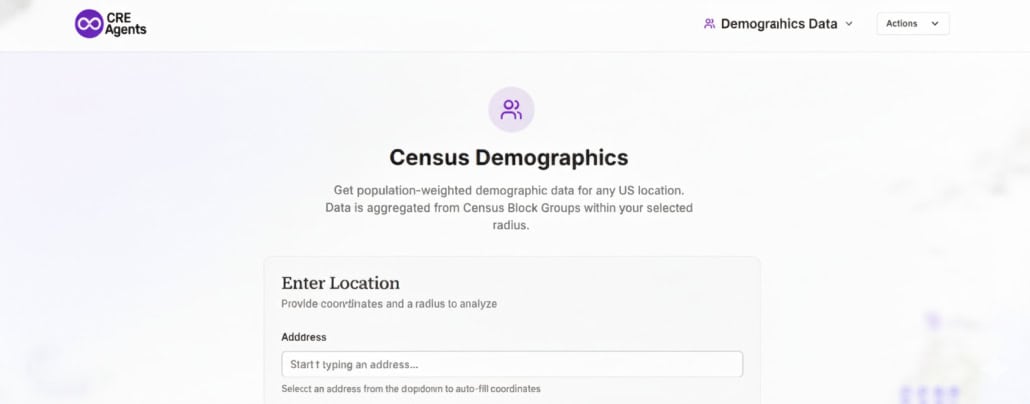
First, go ahead and give it a try. To use the tool:
- Click the button below
- Enter an address and choose a radius (e.g., 1, 3, or 5 miles)
- Wait for the tool to return a clean, attractive dashboard with demographic stats
- (Optional) Click the ‘Export PDF’ button to get a pdf version or ‘Copy Link’ to save the url of the demographic data for that address
- Click the ‘Action’ button in the upper-right to view saved addresses from previous runs or to try a new address
We also built the backend so that our AI coworkers at CRE Agents can use the same methodology in agentic processes (i.e. they can pull in the same demographic data as part of tasks they perform).
How We Built a Defensible Radius-Based Demographics Engine Using Free Census Data
Now, allow me to share the methodology used to build this tool so that you too can build your own radius-based demographics engine.
It starts with understanding the problem.
The Core Problem
The U.S. Census publishes data by block group and tract, not by custom radii. But in CRE, everything is radius-based.
You can’t just average nearby tracts or use distance weighting. And you definitely can’t pretend that block groups are either “in” or “out” of your circle.
The goal was clear: build a tool that delivers radius-based demographics in a way that is auditable, explainable, and institutionally defensible.
Our Four Guiding Principles
- Use only free, authoritative data.
- Work at the finest practical Census resolution.
- Be mathematically explicit about assumptions.
- Fail loudly when the results aren’t trustworthy.
That led us to the following approach.
The Methodology
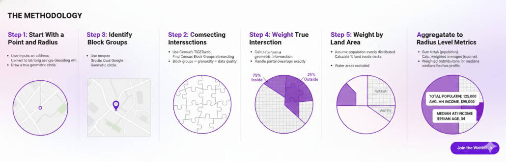
Step 1: Start With a Point and Radius
The user inputs an address. We convert it to latitude/longitude coordinates via Google Geocoding API (the same API included in our Excel 4 CRE add-in) and draw a true geometric circle based on the requested radius.
We verify the geometry before continuing.
Step 2: Identify Intersecting Block Groups
We use the Census’ TIGERweb to find Census Block Groups that intersect with the radius circle. Block groups provide the best mix of granularity and data quality.
Step 3: Compute True Intersections
For each intersecting block group, we compute the actual geometric intersection with the radius. This is critical. Partial overlaps are handled precisely without heuristics.
Step 4: Weight by Land Area
We assume population is evenly distributed within each block group’s land area (disclosed assumption). For each group, we calculate what % of its land area falls inside the circle and weight the data accordingly.
Water areas are excluded.
Step 5: Aggregate to Radius-Level Metrics
We sum totals (like population), calculate population-weighted averages (like per-capita income), and use weighted distributions to estimate medians.
What you get is a true, mathematically consistent demographic profile.
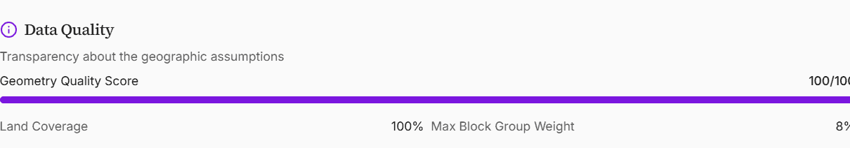
Guardrails and Data Quality Checks
In addition to returning demographic figures, every output goes through internal QA checks:
- Population density outliers
- Coverage area thresholds
- Single-block dominance
- Geometry errors
If something fails, we flag it. This matters since plausible but wrong data can be worse than no data at all.
How We Built It
The workflow started by reasoning through the problem with ChatGPT 5.2 Thinking. Once the logic was sound, I used Replit’s Agent3 to complete the build:
- Spatial intersections using TIGERweb
- ACS queries via Census API
- Polygon math and area weighting
- Aggregation and error handling
- Frontend design and implementation
It’s now fully self-hosted, giving us control over caching, versioning, and performance.
Try the Tool
You can access the tool clicking the button above.
Big thanks to the CRE Agents team for making this (and the Deep Location Analysis tool) publicly available to AI.Edge members and A.CRE readers.
Frequently Asked Questions about Radius-Based Demographics for Real Estate Using AI and Census Data
What problem does this tool solve?
The U.S. Census provides demographic data by block group or tract, but commercial real estate professionals need data in standard radius formats like 1-, 3-, or 5-mile rings. The tool solves this by approximating radius-based demographics using only free, publicly available data with a method that is “auditable, explainable, and institutionally defensible.”
How does the tool generate radius-based demographic data?
The tool uses a five-step process:
Convert address to lat/lon and draw a circle.
Identify Census block groups intersecting the circle using TIGERweb.
Compute true geometric intersections.
Weight demographic data by land area (excluding water).
Aggregate data to generate radius-level stats using area-weighted totals and averages.
What assumptions does the methodology make?
The key assumption is that population is evenly distributed within each block group’s land area, which is clearly disclosed. Water areas are excluded from calculations, and partial overlaps are precisely measured using geometric intersection.
What data sources does the tool use?
The tool uses only free, authoritative data sources, specifically:
Census block group data from the U.S. Census Bureau
Spatial data from TIGERweb
Address geocoding via Google Geocoding API
How does the tool ensure data quality and reliability?
The tool applies internal quality checks such as:
Flagging population density outliers
Monitoring coverage area thresholds
Detecting single-block dominance
Validating geometric accuracy
If any of these checks fail, the system flags the output to avoid presenting misleading data.
Can users export or share the results?
Yes. Users can click ‘Export PDF’ to download a PDF version of the demographic report or ‘Copy Link’ to save or share the URL containing the demographic dashboard for a specific address.
Who else uses this tool?
The backend is integrated into the workflows of AI coworkers at CRE Agents, allowing them to use the same demographic methodology in automated acquisition, brokerage, and agentic tasks.
How was the tool built?
The tool was developed using a combination of:
Logical reasoning with ChatGPT 5.2 Thinking
Replit’s Agent3 for building out the backend
TIGERweb for spatial intersection
Census API for data queries
Custom polygon math, area weighting, and frontend design
It is fully self-hosted for better control and performance.
What are the four guiding principles behind the tool’s design?
Use only free, authoritative data
Work at the finest practical Census resolution
Be mathematically explicit about assumptions
Fail loudly when results aren’t trustworthy


